Wednesday, May 29, 2013

AT - Weverton to Ed Garvey (out and back, with cliff detour)

Once you fall off a horse, it's imperative to get back on as soon as possible


I love ferns.  They're delicious primitive fractals.

I spent Sunday and much of Monday recouperating.  A real "hike" with elevation and rocks and terrain difficulty seemed absolutely out of the question.  But we planned for Tuesday to go, hit at least 750 feet of elevation gain, and a minimum of 6 miles.  I had to re-build the confidence I had and remind myself that I am strong and awesome and won't make the same stupid mistakes again.

So we headed out to Leesburg and then cut into Maryland to park at the Weverton lot.  It's a great place to park - it's near enough to Washington Monument State Park, it's got Ed Garvey on the other side. 


Friendly white blaze!

It'd been raining the night before, with light rain in the forecast, but we figured hey, what's some rain?  We dressed appropriately, and we brought plenty of water.  The hike itself is challenging to normal folks - I believe for thru hikers it'd just be a nice climb - but for those of us who have not yet reached that near-immortal state, it's a slough.  There's an adorable kids hike, which is about 2/3 of the climbing, called the Weverton Challenge that's embedded in this route.  It's actually going to be awesome to take my kids to - it will challenge them but be something completely attainable. 

The way up contains a series of 15 switchbacks over the course of a mile which climbs the bulk of the hill.  At the top of this mile is a junction - you go right for gorgeous cliffs and some fun climbing about, and you go left to continue on the Appalachian Trail.  We decided to do the trail first, and hit the cliffs on the way back.  I'm fairly sure Aaron's thinking was that if I was exhausted and the climbing had been too much, we can skip the steep but short descent and ascent from the cliff. so best to do it second and not first. 

The terrain is the sort that is a combination of medium to large rocks you need to hop between, for about a mile, once you get past the cliff off-shoot.  This gets tiring on your knees after a while, and I sat down and thought, "Is it really worth it?  How much longer is it going to be before good solid ground?"  The breeze was great on the ridge we waited for a bit on, and we continued on.  Then we hit the ideal trail - giving ground, few rocks or roots.  Okay.  It was muddy as hell.  We came back completely spattered in filth. 

We passed by a few weekend section hikers, and a father-son team in Minnesota matching sweatshirts.  We stopped at Ed Garvey shelter for lunch.  It was hilarious - on the floor, dead center, was a graphic novel.  The title:  "I knocked up Satan's Daughter."  I can't really put into words how much that tickled me.  The log book was full of people who'd written their destination, their life philosophy, their attack of the munchies, their warnings of rattlesnakes in the privvy (!!!).  You could tell general ages based on the type of writing "Maine or Bust! Bring the Weed!"  Yes.  That was likely an 18 year old who's taking a break before college.  "Celebrating our fifth anniversary by hiking the trail!" young couple.  There's a feeling that the majority of AT hikers are either very young or just post-retirement.  The evidence matches this, but there are anomalies.  We're not the only 30ish year old hiking couple out there.

The hike back was easier, and the cliff view was spectacular, mostly because the cliff itself looked like it wanted to dive forward, to leap into the air before coming to crash into the Potomac below.  It was a good formation.  The rocks everywhere else were wet and therefore looked black crossed with the brilliant green that signifies new spring growth, but the cliffs were pale grey and gleamed with white quartz streaks in the newly-broken through sunlight. 

We got back to the car and headed for tacos.  Because tacos. 

Time spent on trail:  4 hours 20 minutes, including lunch.
Difficulty:  Medium-hard.  Medium if you're experienced.  Hard if you're novice.
Bonuses:  The Ed Garvey shelter is awesome!  The log book is exceptionally entertaining. 
View:  The cliffs are gorgeous.  The AT itself is a nice walk in the woods.
Kid-friendly:  Slow and steady wins the race.  If your kids are physically active, the 7 miles should be doable but it's going to be tough.  Prepare to carry them at points.


Sunday, May 26, 2013

Dehydration + 50 degrees = hypothermia and other assorted ills

The subtitle of this post:
AT - Pen Mar heading north

This post is actually really hard for me to write.  Aaron and I were setting out on a four day backpacking trip and there were several critical error points.

Critical Error Point #1:  We met our shuttle from Pine Grove Furnace to Pen Mar and went and had lunch.  After lunch, I realized we forgot our trekking poles. I'm blind in one eye.  I do not hike without trekking poles.  I said, you know what, it's only 40ish miles.  We'll be fine. We couldn't turn around - at that point, we would not have made it to a shelter in time to pitch the tent and make dinner before dark.

Aaron brought us each two big bottles of Gatorade.  We also have a good water filter.  The intent here is to drink the Gatorade bottles, then fill with water, minimizing the stuff we have to cart around.  Have I ever mentioned that I don't tolerate processed foods well?  Gatorade is intensely processed food and I started coughing, fairly regularly.

Critical Error Point #2:  I decided to lay off on drinking and catch up when we made it to a water source.

 Our day started with a climb of about 1,100 feet.  Total elevation gain was approximately 1,500 feet for the day. My lungs, with the Gatorade, were unhappy.  I was wheezing, and my chest was very tight.  I had to hit my inhaler several times.

Critical Error Point #3:  I hit my inhaler a few too many times, but I needed to to breathe.  This causes dry mouth and dry throat.  Muscle cramps.  Insomnia.  It's not going to kill you - but it's not awesome.

Now, the bonuses.  The hike was gorgeous.  I felt very awesome about myself after the climb, and even as my legs trembled towards the end of it, I felt like hey.  I'm going to be able to do this.  The stream at Antiem Shelter is beautiful, really lovely, and criss crossed by this network of tiny bridges to get from place to place.  There's a freshwater spring about 3 miles back on the trail from Antiem which has a nice place to sit and rest.  The ferns are amazing. 

But back to my tale of errors.

When we got to camp, Aaron set up the tent while I boiled water to make rice for dinner, and dehydrated pea soup.  I put on a layer of clothes as it was about 58 degrees, nice fleece warm pants, a long sleeved shirt.  I was dizzy, and very tired.  I made food and my teeth were chattering as I worked over the small fire camp stove.   Hot food would warm me up, I said.  I still didn't drink much.  I did, some, but not enough to replace all the coughing water lost, the sweating, etc.  I ate my soup - all 150 calories of it - and didn't feel like eating more.  I forced down a few bites of nutella and crackers, and brown rice.  I knew 150 calories was not enough and I would wake up utterly miserable.  But I was cold.  I climbed in the tent and put on two sleeping bags. 

Critical Error Point #4:  I began to cry.  I was cold, and I was scared, irrationally.  I should have recognized this as a Sign Of Trouble, but I didn't.  I don't cry.  I'm not a crier.  But here I was, crying away.  What the hell - and I didn't flag it at this point.

So I put socks on my hands, nice thick wool ones, and I wrapped scarves around my head to prevent heat loss.  I added more shirts.  I had on pretty much every article of clothing we brought with.  Aaron was in his hiking shirt and his lightweight shorts.  He was warm enough, no problems.  I felt like it was 20 degrees - in reality, it was just over 50. 

My teeth chattered and there was no hope for it.  Aaron called the shuttle driver who gave us a lift earlier, after we spent two hours in the tent trying to sleep and warm me up.  I was chattering non-stop.  I tried to take a benadryl to help me rest, even, and maybe tamp down my cough a bit.  Nope.

He agreed to pick us up - he's amazing, named Mike, and he's a hiker-rescuer.  He came, and it took about an hour because the high concentration of deer on the backroads requires slow, deliberate driving. 

I felt like a damn failure at this point, but I still didn't know why I was so cold.

I got into the car and slowly warmed enough that I fell into a confused sleep.  Aaron transferred me to our car and I slept fitfully, screaming every couple of minutes to "watch out!"  One conversation went, "Slow down!" "Why?"  "I don't know!"  And I was asleep the whole time - I have no memory of babbling.

We got home at 3 AM and I was so sick.  So sick, and dogged miserable, our housemate took me to the ER where they re-hydrated me and my body learned to control its own internal temperature once more.

So here I am on day 2 of my AT hike.  In my pajamas, on my couch, sipping coffee, having napped most of the day.

Tomorrow we're going out again.  Tuesday we're going out again.  Lessons learned are important and we don't grow without making mistakes - but man.  Newbie mistakes almost caused huge health problems.

The trail was gorgeous and peaceful.  The other distance hikers we chatted with were friendly, and two had dogs carrying water packs with them.  Despite all the critical error points, I call the day a success.  It afforded the opportunity to show that I can recover even from really dumb mistakes, I can survive even when making really dumb mistakes, and I can do better next time by not making the same mistake twice.


Wednesday, May 22, 2013

Packing List and Gluten Free Hiking Meals

Aaron and I find ourselves without children for Memorial Day weekend.  We've decided to make a 4 day hike out of it, backpacking along 50ish miles of the Appalachian Trail.  This is going to be a huge event for me, but what amazes me most is the idea of a packing list.  I ask myself, what will I need when setting away from technology for 4 days?  I'll have my iphone but I will only be using it for photos, and a call home at night. 

Eventually we nailed it down to this list.  I keep staring at it and thinking I'm forgetting something!  The food was a difficult bit - I eat no chemicals and I'm gluten free, and as we'll be burning about 6,000 calories per day, I'd kind of like to consume at least 3,000 - which is hard for me, who is used to about 1700.  But I think we've got a plan in place that should feed us.

** Food
Breakfasts:
Oatmeal packets
Pecans & Craisins
Folgers coffee singles

Lunches:
Perky turkey jerky
Trail mix with 72% dark chocolate, cashews, almonds, raisins
Dried apricots
Dried pineapple

Snacks:
Snickers bars
Glutino cereal bars
Sunflower seeds, already shelled

Dinner:
Dehydrated peas
Dehydrated potato buds
Organic split pea soup mix
Chicken bullion cubes, also organic
Crunchmaster crackers
Nutella

** For Sleeping
Tent Body   
Tent Poles/Stakes
Winter Bag  
Summer Bag
Underquilt  
Tiny pillow  
Nightlight  

** Clothing-related (1 stuff sack per person)
Shoes   
2 pair hiking socks
2 pair Ex Officio 
4 pair microfiber 
Hiking shorts/capris
Hiking top  
Sleeping top 
Comfy bra  
Sleeping socks  
Orange fleece   
Long sleeve shirt 
Flip flops for Jen 

** Food-related (in a bear bag and other)
Stove   
Fuel and spare
Aluminum Pot
Spoon   
Small container dish soap
Cup   
Lighter and spare
Water Filter  
Water bottles
Food  
Paracord (for bear bag) 

** Toiletries Bag
Toothbrushes   
Toothpaste  
Purel   
Small bottle lotion 
Body Glide  
Baby Powder
Bug Spray
Sunscreen
Floss   
Needle  

** Medicine Bag
Neosporin  
Band aids  
Alcohol Wipes
Vitamins   
Ibuprofen 
Benadryl  
Immodium  
Breatheright strips 
Tums   
Inhaler
   
** Miscellaney
Packs   
Pack Liners (2 ea trash bags)
Beltloop watch   
Camera/Cell  
Headlamps 
Cash/credit cards  
Trekking poles  
Duct Tape (on pole) 
Camp Towel  
Baby Wipes   
Knife    
Maps and guide   
Pen and paper  
TP and trowel
Plastic baggies 
Deck of cards  
Iota   

Tuesday, May 14, 2013

Hiking By Night?

Last night I was restless and wanted to go hiking.  I didn't terribly care that it was 8 PM and already the evening blanket was beginning to settle.  Aaron, says I, put on your shoes.  If we don't go now,  I'm just going to go to bed.  When I go to bed at 8 PM, I am awake by 4.  There's just no arguing with my body - 7 hours of sleep is my preferred and I just can't sleep any longer no matter how hard I try.  Not being a fan of waking up with me at 4 AM, Aaron put on his shoes and we set out in our neighborhood.

I'm not certain I've spoken much about my neighborhood.  It's a big, friendly place full of families and dogs and well-manicured lawns.  Townhouses are set like teeth into the lanscape that surrounds the pipeline that runs through Northern Virginia.  The pipeline has nothing built over it anywhere, and the trees are cleared from it.  It is simply a giant swath of prairie grass framed by trees and houses, over which airplanes fly.

Think of airplanes as white noise.  When the comings and goings are constant, it's like the ebb and the pull of the ocean.  The sound becomes comforting and settled - they are not so close as to be a disturbance but more as to be a friend. So with this white noise and the settling night, we set out. 

At first it was wonderful.  We passed one jogger and three dogs being walked.  It was very quiet, for our neighborhood.  It felt luxurious and a bit irresponsible - as though we, too, should be settling. 

We decided to take a long loop that should take approximately one hour.  Nevermind that this loop goes through forest at night!  It'll be fine!

As the sun sunk lower and lower, I eyed the gaping black forest we were about to go into.  Any of you who live in urban areas know there is no real darkness here, but somehow in contrast to the safely lit streets, those paths seem darker than an alley in a ghost town. 

I'm afraid of the dark.  It's okay.  I said it.  I'm fine with this weakness, really.  The tiny town I come from in Northern Wisconsin experiences darkness, true darkness.  The stars are alive there - the milky way and the aurora borealis are visible at times, and the moons light is enough to see deer and bear dart and lumber through the yard, respectively.  Here there are few stars, and fewer lumbering things.

But the darkness scares me.  I was reading about two hikers, women, who were murdered on the Appalachian Trail in 1996, and I was none too sure that there weren't things that go more than bump in the night.  There have been eleven murders on the trail since 1974.  I'm none too keen to become the twelfth. 

Aaron said all was fine, and he took my hand and we walked down into the dark trees.  We came to a stream crossing.  Under the bridge, a bubbling blackness was seeping through the cracked boards.  Gollums lurk in the darkness, gollums and conniving snake dens and unknown things with fangs and fingers and fur.

And so our leisurely walk turned into a jog, and a flat out run.   I was overcome by my imagination, I fear, and had I been able to fly, I would have flown over the bridge.  Hearken back to when you were six, and things could reach out from under your bed and grab your ankles and pull you under, forever and ever.  But your blankets protected you!

Well hell.  My blanket was nowhere nearby.

Aaron, the fine husband he is, chased after me so as not to leave me alone.  After racing down the path faster than I thought my legs could carry me, we came to terrain that was bordering houses.  These houses had their lights on,  behind drawn shades, and the ambient light was enough for me to feel invincible once again.  So we meandered over another stream.... okay.  I say meandered.  He meandered.  I took a running leap over it.  Same difference.

And then we came to the clear swath again.  Only now the darkness was more firmly entrenched.  There was a bare fringe of fuschia around the horizon, fading up to rose and then blending with tones of green grey and smoky darkness until the sky above was a deep shade of slate that bordered on navy blue.  Polaris was visible, and the crescent moon could clearly be seen to be nestling the rest of the moon, in deep relief, in its palm.

And the airplanes.  Oh, the airplanes.  I was stunned by the beauty of these moving stars, not shooting starts but crawling.  I could see so many all at once, following their varied paths across the sky.  One looked to be going straight up, until the light grew bigger and it passed overhead, the twinkling on the wings visible it was so close.  Others seemed to be falling into the houses on the horizon, getting caught in the blackened leafy branches of trees.  Some arced through the sky, west-bound.  One by one, more stars appeared in the sky and the rosy shades disappeared from the horizon entirely.

As we stood there in dumb silence watching for what felt like an hour, I realized that hiking by night might not be for me.  But pausing to focus, really feeling that internal stillness, contrasted with the cross-country movement of so many in the skies above? 

Yep.  That's for me.

(No photos.  They would look like a big blotch of blueblack.)

Monday, May 13, 2013

Claude Moore Farm Trails

Life interfered with hiking for the past three weeks.  Aaron and I were able to walk about our small neck of the woodlessness, but we were not able to get out and do any hiking.  Aaron got laid off, he's been job hunting aggressively, I've started a new job with hours that do not lend themselves to exploring the world at night, and so it goes.  Best laid plans, and all. 

So for Mother's Day Weekend, I wanted to hike.  We had Sky Meadows planned for Saturday, and were looking forward to it.

Saturday dawned with a grey dampness that can only be described as being inside a wet pelican.  Saturday, then, was a yard sale and a bit at a park, just playing, until the undue sticky could no longer be tolerated, and we fled for the safety of air-conditioning. 

Sunday I teach in the morning, and afterwards, it was time.  We decided on a nice, flat, nearby place.  We choose Claude Moore in Sterling, which is, I must say, really adorable.  The hiking trail we were on was 2.6 miles, nothing fancy.  The trails are interesting - some are like roads, but our choice was this trail which wasn't so much a trail as a slight break in the trees and a path entirely of knee-high grass.  It was lush and green with the new green of early spring - not a Kermit fuzzy green but a caterpillar eye.

And oh, was it muddy.  And snakey.  And tadpoley.  Millions of living things are beginning to wake from winter slumbers and each and every one of them wanted to say hello.  The tapoles in the streams and pond water striders skittering across the surface, were excited to be a part of this crisp and cool day.  Squirrels without number, chipmunks and even what I suspect was a young clutch of birds watching us nestled in a stump were abundant, and yes, even snakes were out with their whippy tails and their glass skin.

It was a gorgeous day! 

The nature center had this wonderful little scavenger hunt of the living world.  The only thing we did not find was a blue heron - I suspect we would have, had the mud not driven us away from certain areas.  The mud was the slick sort and not the sticky sort, so that knees and legs were spattered just as evenly across all people.  Julia, Kate and I all slid but nobody fully fell - Julia came closest.

And then there was a farm museum, which was tiny and adorable and had tractors for exploring outside, windmills to teach about responsible energy, and a bathroom to chase away Julia's hives.

Happy mother's day to me!

Time Spent on Trail:  90 minutes.  Too wet to explore most places.
Difficulty:  None.
Bonuses:  It's ALIVE!
View:  Beautiful if you want trees and greenery and swampy wetland things.  Not so much if you want mountains and expansive view - it's the micro and not the macro here, but the micro is just as lovable.
Kid-friendly:  Yes.  It's designed for children and has "hikes" as short as 1/2 mile.


Tuesday, April 16, 2013

Great Falls Loop with Difficult Run (VA side of Great Falls)

Aaron and I have Kate, a friend of ours who wanted to go hiking with us.  We are always happy to hike!  And we had planned a large loop at Sky Meadows on Sunday, but Kate hasn't been hiking in a while, and so we decided to start out with something easier, but with known beautiful views and thereby rewards for the hard work.  Great Falls is close to home, and it was a gorgeous day, so we set out there.

We began down by Difficult Run.  Our intent was to follow Difficult Run to where it loops with the Ridge Trail, then to River Trail and then the Visitors Center, Old Carriage Road and Swamp Trail and Ridge Trail and a jog back to the parking lot.  This would have worked out to be a nice easy hike of 5.1 miles - except for the river washing out the path.  With our detours it was harder and 5.7 miles.

We were walking by an adorable family with two kids half-climbing a cliff that was half roots and half Virginia red dirt and much rock.  The dad said to us, "This is the easy way."  We laughed and then looked around the bend ahead.

He was right.  That was the easy way.  We investigated continuing - and then I thought of Kate.  I thought even Aaron would have a hard time going down then back up on these craggy rocks that had no actual path anywhere nearby and it looked like you had to hand over hand it across a section.  I thought, hey.  Up's easier than down.  We headed back to the place the little kids, who must've been part mountain goat, were still working on.  Up I went, then Kate and then Aaron. 

According to Kate's fitbit, approximately 170 feet elevation later we stopped climbing it.  She said, "Man we should've taken photos.  Nobody's going to believe we did this."  There was an unmarked unofficial trail, but clearly well worn, up to Ridge Road.  We took it, then went right on the road.  We should've gone left - but we met a nice group of friends who were hiking as well, and the view of the Potomac is breathtaking, really, from most of Ridge Road.  We corrected our course and kept on going.

My rating of the hike is sub-optimal because there were approximately 9,673,223,100 people who decided today was THE DAY to go hiking at Great Falls.  I prefer my nature with a good dose of quiet and peace and focus.  Andy, the poodle we met in our travels that day, didn't agree - he seemed to be having a grand time running around and meeting people.   (Approximately 1/4 of those people brought their dogs, you see.)

But the views of the river were gorgeous, and it was fun to watch people from our vantage point of the VA side scrambling up the Billy Goat Trail on the MD side.  I decided I don't actually want to hike it - the challenge wouldn't be really anything harder than climbing the path-that-was-not-a-path, and there was literally a line that looked ten minutes long to continue up a section we were watching.  Not my thing.  But everyone was dressed so colorfully!  And it was like watching cars on a highway from the overpass above - an endless stream of people - which has a beauty of its own.

I loved the valley of trilliums we passed through after the Visitor's Center.  I did love people-watching, during snack break - I love to try to imagine everyone's back-story and just how did they come to be where they are now?   I love that each of these people has a full story, and events that shaped them, and that to them?  I'm as much a crowd face as they are.  That's part of the beauty of hiking, actually - when you're out in the woods, you are a small thing - and you feel the world as a large thing.  Sometimes in our city lives, we get caught up in work and friends and just our own process of everyday living, everyday decisions, everyday framing of the ordinary.  The extraordinary can get overlooked.  When you're hiking, and you've been working to get to that ridge, up there, the view from there seems to be somehow more - more amazing from being earned, and more coveted from being attended fully.  It is a reminder to pay that sort of attention to things in our non-hiking lives - to fully attend each thing and try to be a participant in its beauty.

I guess that's why the scores of people on the trail don't bother me much at all, in retrospect.  That was their moment to work for and appreciate beauty.

Time spent on trail: 3.5 hours (including a long stop for snack and many photos)
Difficulty:  The planned hike was easy.  The executed hike had a very difficult 15 minutes, and the rest was easy.
Bonuses:  The view is stunning, the photo opportunities endless.
View:  See above.
Kid-friendly:  Yes, though you'll have a heart attack when they climb the cliffs of insanity.  Maybe start out NOT at Difficult Run.


Tuesday, April 9, 2013

Bull Run Mountain

Having discovered that yesterday, Monday, was over 80 degrees, Aaron and I decided to pack it in just a tiny bit early from work and go to Bull Run Mountain.  At the moment, I have not started my new job, and he is able to work flexible hours, so we were able to head out at 3:00 PM.  We knew it was hot, and we didn't care.  Skimpy tank top and jeans and good shoes?  Check!  Pints and pints of water and gatorade?  Check!  Bandana for sweat control?  Check check!

The drive was short.  Bull Run Mountain is the nearest climbable mountain to Washington DC area, and it was a good target - being against traffic on the return trip, unlike some Maryland climbs.  The elevation gain from where we parked to the overlook was 700 feet.  That's 70 flights of stairs.

I approached this with the air of one going to take out the damn trash.  It's a thing that must be done and therefore, by god, I'm going to do it.   Readers, one thing you must know about me is I am not in prime shape.  I'm getting there!  And I have made a commitment to undo years of exercise neglect my body has gone through.    I believe for someone in peak shape, a 5.5 mile hike with 700 feet of elevation gain would be a walk in the park.  For me, this was a supreme challenge but on my quest to eventually be a hiker for weeks at a time, I need to be able to conquer elevation.

My inhaler, my ibuprofen, my husband and I all climbed this mountain together.  Each time I stopped to drink and catch my breath, I didn't feel a failure for stopping - I felt a success for keeping moving.  I felt a brilliant glow of accomplishment for taking those steps up that mountain.  Each time I stopped just reminded me I am human, and I have to keep moving to find my stride. 

That's really what this journey is about - my stride.  I have a partner whose stride matches mine, and I am so very, very lucky.  We need to find the rhythm that makes our bodies sing.  For me, that's being outdoors with the sun and the wind and trying new things, hard things.

And so I won't pretend that this wasn't hard.  It was - the way up took twice as long as the way back down.  But at the top, we stopped and sat on an outcropping of rock.  (I climbed up the boulders to sit!  Another thing that I never would have done three years ago!)  My feet were at the edge, and just past them, raptors flew up and down the ridge.  They would glide through the sky, their outstretched wings seeming to be motionless, though they were making swoops and dives.  I couldn't see their nests, but just to be among them, almost conversant...

That was the theme of the day.  Amazing.

Time spent on trail:  2.5 hours
Difficulty:  Moderate-hard - if you're good at climbing, moderate.  If not, it's a toughie.
Bonuses:  Self-esteem and accomplishment.
View:  Raptors!  Hills!  Valleys!  Ridge lines! 
Kid friendly:  Yes, for older children.  It's tough and would exhaust most small ones.


Prince William Forest

I am a few days behind, I regret to say.  This hike actually took place on April 3.  It was the first actually genuinely nice warm lovely day in the Washington DC region.  The weather was cool at first, and I wondered if I should bring a jacket.  I wore layers, a paper thin shirt under a t-shirt and a fleece over that.  Within 10 minutes, the fleece was in the pack, and within 30, the under-layer came off as well.  The sun filtered through the trees and looked as much like elfin dancing beams as I'd ever seen.

The Prince William Forest is a young forest.  If you look at the photo above, there is a sameness to the landscape which is fascinating.  The trees are mostly short, and it allows a good bit of light in - especially in the young springtime.  I'll be excited to see how it greens up when the season turns.  The trail is beautifully maintained, and in fact as we arrived, there was a woman pushing what looked for all the world like a unicycle for a cat.  This was, as Aaron informed me, a trail measuring device.  I wanted to know how she planned to ride it, you see.

About half a mile from where we parked was a campground.  A quaint old, old water tower was there, public restrooms, picnic facilities.  There were tiny cabin-looking structures that were public science experiments!  I'd love to hear someone talk about the kinds of experiments going on in those tiny sheds. I thought from a distance they might be really nice, rather new looking out-houses, but no - they even have a window box and a tiny paned window, and are more narrow than the door to my deck.

The day was quite quiet - people were around, but not many.  It felt like a well-kept secret.  Easily the best part was the waterfall.  We chose it, approximately three miles in, as a snack and rest stop, sitting on the sun-warmed rocks right at the edge of the water.  We could've dipped our feet in, had it been just a hair warmer than it was.  These photos of Aaron and I were taken at the waterfall area on our stop. After our break, we decided to not go the entire 8.5 miles we'd been planning, as the traffic around this area can be quite horrible late in the day and we wanted to make sure to get home in time to make dinner.  And get home on time we did!


Time spent on trail: 2.5 hours
Difficulty:  Easy
Bonuses:  Waterfall, nice clean bathrooms and easily accessible water, myriad options for hike length and setting-out points
View:  Foresty - not spectacular, but the walk is pleasant enough that it's not view-motivated
Kid friendly:  Very


Sunday, March 24, 2013

The Appalachian Trail - Weverton to Harper's Ferry

I am going to open this post by admitting that this was a difficult hike for me.  The ground is not what I like when hiking.  Instead of trail, with variance, rocks, heights, etc, you would up walking 3ish miles each way on hard packed loose stoned ground where the trail and the C&O are one and the same.  I don't enjoy that kind of trail - it leaves my shins feeling pained and my body fatigued.  The more natural cadence of forgiving ground, complete with roots and boulders and all, is far more hiking friendly, in my opinion.

Because I got so exhausted by the end, from the monotony of the ground type mostly, my  opinion of the hike deteriorated GREATLY in the last mile.

That said, we chose a trailhead about 1 mile down a giant hill from the Harper's Ferry Hostel where Aaron (on the trail known as Rockfight) stayed during his trail journey of 2010.  There's a 1/2 mile lead-in to the C&O which is beautiful, actually, a mix of good views and interesting trail as it wends a thin loop just on a precipice above a feeder river to the Potomac.  Once we got to the parking lot of the C&0 at Weverton, we decided to walk the mile up the giant hill to the hostel, so I could see where Aaron had stayed.  It's charming, actually, and I'd recommend it highly based on the atmosphere.  It feels welcoming, friendly, as though you're a sanctioned club member, or something!  The caretaker of the hostel was inside, though it's not open until April 15, doing laundry and maintenance.  She let us in, and I was very impressed.  It had the feel of a bed and breakfast.

We sat on the deck and had lunch, admiring the Potomac below.  We decided to take the blue-blazed trail down to the C&O, which was difficult and really delightful - with one exception.  (In my eyes) there was a downed power line which had been cut!   Aaron ASSURED me that there was NO power in it (in fact, it was not power line at all, just a cable that LOOKED like a power line.)   I started looking for a way around it, and spotted a path which would've been frankly stupid, and he coaxed me over the "power line."  We were fine.

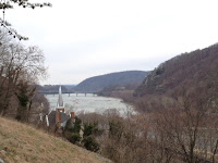
So we made it over to the C&O and walked to Harper's Ferry.  The winter views of the Potomac were, in fact, stunning.  I wouldn't recommend anyone do this in the summer.  The growth will cover the river, block the breeze, and there is a ton of stagnant water that will breed any number of bugs.  But in the winter, this was really beautiful.

Harper's Ferry itself was also equally beautiful.  A coffee shop there had excellent coffee and?  Gluten free coffee cake!  Heaven!  We bought some to save for the post-hike starvation on the way home.  The town itself is a blend - museum, kitschy little "recreated" taverns, gorgeous old architecture, historical sites and views.  Oh, the views.  Old bridge trestles dot the Potomac here, with trees growing on top of them, and Jefferson Rock is all he boasted it to be.  The confluence of the Shenandoah and Potomac is simply stunning.  Even on this cold, cold day it was full of people, and many distance hikers (possibly training).  Everyone was friendly and it was honestly a beautiful hour we spent meandering about, inspecting this and that.

We decided to head back.  I really wanted to be home by 5:30 - I wanted to make dinner, and pick up a bit!  And...!  And all kinds of things!

So we are walking.  And walking.  Around the sixth mile, pain set in.  It sort of crept over my body, the kudzu-like pace increasing as my pace increased.  So we slowed, had some trail mix, slowed.  I honestly hurt so much I was prepared to just stop there, wrap in sleeping bags, and whine.  Like the British, I "carried on" though, and heaved myself back to the lovely soft trail that wound its way back up to the parking lot.  Even the stubby little dog we passed seemed tired of it by the time we passed them again.  (Or, you know, they passed us on the way back to their car.  Because yes, we were passed by stubby dogs.  I was moving slow!)

The soft trail rejuvenated me a bit, and my pains ebbed.  I began to imagine feeling it subside completely, I counted the falls of my hiking poles and feet among the soft and the rock.  It was with relief we made it back to the car.

And now,  I will eat my Chipotle and revel in the softness of my couch, the fluffiness of my cats, and the warmth of blankets and butterfly pajama pants. My next path will not be as unyielding as the C&O. 

Time spent on trail:  4 hours 15 minutes.
Difficulty:  Without the detour to the hostel, easy but tiring - the firmness of the road is not good for long distances.
Bonuses:  The winter views of the Potomac, the charming hostel, the gluten free coffee cake, the thousand steps leading to Jefferson Rock.
View:  Winter superb, I would imagine summer it would be gorgeous in Harper's Ferry, but not so much on the C&O.
Kid friendly:  Park much closer to Harper's Ferry than we did and it would be an amazing place to take children.  They, however, will not enjoy the long walk with so much monotony.


Monday, March 18, 2013

Donaldson Run and the Potomac Heritage Trail

Sunday was a very busy day.  I teach sixth grade religious school, and we had a mock wedding in which we married off two couples from each class.  It was hectic and a bit scattered, being a new event for the sixth grade teaching team.  Despite being crazy busy, it came off beautifully and we got everything done.  The upshot was about 8000 steps in patent red leather kitten heels before I even headed out to the trail.   When Aaron brought my high-protein lunch and my hiking clothes I looked at them - the obstacle standing between me and my couch and my fluffy cat and some nice coffee.   Still, it would be better to walk ouside, I knew that, and my hips would thank me for the natural rhythm of foot to giving ground. 

"All right.  2 - 3 miles though, I want to be home by 5 to make dinner."

Aaron agreed and we set off.  He said we'd be starting near Potomac Overlook Regional Park, which really was lovely, and so I was glad to be going.  We headed down the trail and he said we'd be practicing crossing streams, as Donaldson Run crosses over this little river feeding into the potomac about 12 times, keeping the trail just along the river.

We get to a steep down - not quite a cliff, but down about 120 feet, that leads right to the bank of the potomac river.  Now, readers, I am not a small girl.  I'm not as rugged as I'd like to be.  I was a bit anxious, because a false move and I would've gone face first far enough to break SOMETHING.  But down we went, and I was glad we did. 

The view of the potomac was beautiful.  The sky was grey, and birds of prey were gliding overhead, swooping to grab fish from the river itself.  Their talons left trails along the glassy surface.  Greening hasn't happened here in DC yet, and in fact, it's quite snowy this morning, so the air smacked of winter and fire.   We sat a bit and had some trail mix, some water, and just enjoyed the serenity.  No traffic could be heard, and I was watching two people on the Maryland side across from us fishing in silence.

Then I looked back up.  No.  No - I was not at all interested in climbing back up.  "Aaron, if we walk further away surely we'll come to a different place to get back to the road and then go find our car."  He agreed, yes.  This was the Potomac Heritage Trail, and there are many ways to get back to the road.  We set towards Chain Bridge.

They use the term "trail" quite loosely.  This was the Potomac Heritage Boulder Scramble.  For half a mile, we traversed over very rocky terrain, at times having to throw our poles over the next boulder because we knew we'd need both hands to get up and across.  (I say we.  Aaron's hiked the Appalachian Tral.  He was fine.  When I incriminate him in the scramble-picking, I'm really just talking about ME here.)

We come to a green blaze side by side with a blue blaze.  This!  This will be our way back out of the river area! 

This turns out to be a nearly 200 foot cliff.

Fine.  We've just gone over half a mile of Bouldertown.  It can't be THAT bad.

At one point, I grasped the iron railing, which was a remnant of old days and not actually stable anymore, and swung my butt off to the left to shimmy around a crag and find footing on the far side. 

It was then I felt nearly immortal.

Once we climbed up and up and up and up, we got to the road and walked 3/4 mile back to our car.  It amazed me how much better trail feels under your feet, even when rocky, than ungiving pavement.  Aaron was true to his word, it was 3 miles on the trail.  And yes, we were home near 5.

All in all, an amazing afternoon.

Time spent on trail: 2 hours on the nose.
Difficulty: Difficult for inexperienced hikers, moderately difficult for experienced (Aaron said it was about the hardest thing you'd find each week on the Appalachian Trail.)
Bonuses:  You will feel like you can kick death in the shins afterwards.
View:  Amazing views of the potomac - you're practically in it.
Kid friendly:  If your kids are experienced hikers, it'd be very fun for them.  If they are not hikers, Donaldson Run itself is kid friendly, and fun to cross stream after stream, but don't go down to the river.

Wednesday, March 13, 2013

Potomac Overlook Regional Park

With Tara and Anna and Julia and Aaron, we needed a place to spend a warm spring day.  The zoo is right out - there's no parking there and it's not good when you only have a couple of hours to spend - certainly it takes over an hour to get to the zoo!  Aaron knew just the place.  He started his journey along the Appalachian Trail from this park just a couple of years ago.

The picnic and playground facilities were nice, and then we headed out to hike.  It would be an easy hike, not much climb, and it would get us out of the house.  The girls and I were varying forms of feeling under the weather, but fresh air does a body good.

We headed down the trail and it was very peaceful.  Sure, there were people there, but it certainly wasn't crawling with people, and had a variety of delightful dogs available for petting and visiting.  The overlook itself is a joke.  Do not go to this park if you want to ooh and aah at the Potomac River.  There are many other places to do that - this has virtually no view of the river.  Don't let that deter you from coming here if you want to enjoy a nice family hike, however!

The nature center is something to behold.  The girls loved the park, more than they even wanted to go to the zoo.  A pond of frogs charms near the community garden, and the nature center building itself is wonderful.  Hands-on exhibits delight children of all ages, and a display of various live snakes manages to be educational and smart and not at all frightening, even for a snake-o-phobe like me.  There is an ampitheater, there are trails that wend through an Indian Circle Garden, and there are so many things to explore.  Small explorers will find hours and hours of things to look at.

If you get tired, there's a service road that's a quick hike back, though you can wend your way on trails for just over 2 miles.

Time spent on trail:  Hard to say.  Overall we spent 3 hours in the park, but much was ooh-ing and aah-ing at things.
Difficulty:  Easy.  There's some uphill climb, but nothing challenging.
Bonuses:  The nature center is delightful, wildlife abundant.
View:  Beautiful trees and light and colors.
Kid friendly:  BRING YOUR CHILDREN HERE.  Do it.  You won't regret it.


Tuesday, March 12, 2013

Eleanor Lawrence Park, Northern Virginia

Aaron and I went home from work and had a quick snack.  I insisted that we eat standing up - I knew that if I sat down, it would be far too easy to be distracted by any number of stationary objects.  Furry cats, compelling computer games, things demanding reading... no, we had to eat standing up and get our hiking shoes on immediately.

I didn't actually bother changing out of my work clothes.  I wound up hiking in my hiking shoes, pinstripe pants and a light sweater I wore all day.  We grabbed bottles of water and set out.

The hike itself was 3.4 miles, a figure 8 that looped through thick wooded land.  It amazes me to find swaths of forest where you can imagine that you don't hear the constant drone of traffic, and you can really picture yourself on the trail, nestled in Northern Virginia, but they do exist.   We set a brisk pace and climbed the steep first, heading down the gentle slope.  I like to get up out of the way all at once if possible, as opposed to gradually, more because I find going down more difficult.  It's the challenge of hiking with one eye - distances are very deceptive.

I think my favorite part of the hike was the stream with the stepping stones through it.  They were wide spaced, able to leap from stone to stone, but right next to a bridge - the option was there either way.  Also beautiful, a tree with initials carved in it - not just two, but the whole tree as far as arms can reach, lightly etched.  It would not have been beautiful had they been all over, but as far as we could see, there were just two trees that were so inscribed.  Some of the initials have been there for decades - you can see by the fading and the slight growth around them, the stretching as they grew.  There were also random spots of bright green, new growth of daffodil and moss, primarily, which were a welcome spring-heralding sight.

We found the south loop only took us about 35 minutes, so we continued on our way.  The problem with hiking after work is balancing the need to make dinner with the need to get out and about.  Evening hikes need to be 2 hours at the very max, and that's if work gets out a bit early.  Well, at least until summer anyway.  Once that light is up until 9, the hiking possibilities open up widely.

Time spent on the trail:  65 minutes
Difficulty:  Easy - even for someone a bit out of shape
Bonuses:  Many benches for resting, taking photos, picnicking
View:  No overlooks, but many trees - at this time of year it is very grey-brown and tired
Kid friendly:  Absolutely